Modelación hidrológica con el modelo SWAT empleando diferentes distribuciones espaciales del tipo suelo en la cuenca del Río Mixteco
DOI:
https://doi.org/10.28940/terra.v41i0.1566Palabras clave:
área de drenaje, balance hídrico, mapeo digital de suelos, producción de escurrimientosResumen
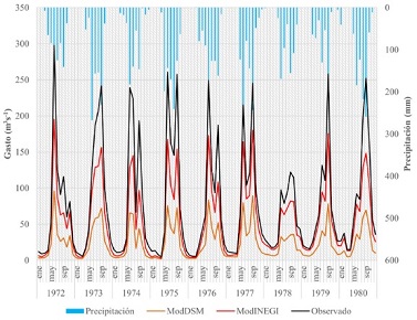
La cuenca del río Mixteco se ubica en el estado de Oaxaca, México y comprende una superficie total de 6 559.20 km2; esta presenta fuerte degradación de sus recursos naturales, derivado principalmente de las acciones antrópicas asociadas a una mala administración de sus recursos naturales. El objetivo de este trabajo fue evaluar el comportamiento del escurrimiento superficial mediante el modelo SWAT (Soil and Water Assessment Tool) en la cuenca del río Mixteco utilizando tanto la distribución espacial de suelo del INEGI (Instituto Nacional de Estadística y Geografía) como la obtenida a través de la técnica de DSM (Mapeo Digital de Suelos). La modelación con INEGI (ModINEGI) correspondió al mapa edafológico de la Serie II escala 1:250,000 y la modelación con DSM (ModDSM) se obtuvo a partir de covariables ambientales. Los indicadores de evaluación del desempeño del modelo SWAT durante la fase de calibración fueron R2 = 0.88 y NSE = 0.87 para ModDSM y R2 = 0.85 y NSE = 0.85 para ModINEGI; sin embargo, durante el periodo de validación, los resultados de ModDSM (R2 = 0.83 y NSE = 0.81) fueron mejores que los de ModINEGI (R2 = 0.83 y NSE = 0.61). Por lo tanto, los resultados indican que la variación espacial de los tipos de suelo obtenida a través de la técnica de DSM, en combinación con la cobertura vegetal y la distribución de las pendientes a nivel cuenca, permiten al modelo SWAT simular de forma adecuada el comportamiento del escurrimiento superficial.
Descargas
Publication Facts
Reviewer profiles N/D
Author statements
- Editor & editorial board
- profiles
- Academic society
- Terra Latinoamericana

Para obtener más información sobre un dato, haga clic
![]()
PF is maintained by the Public Knowledge Project