Supervised Classification for Mapping Forage Maize Using Remote Sensing in the Laguna Region, Mexico
DOI:
https://doi.org/10.28940/terralatinoamericana.v43i.2123Keywords:
algorithms, Sentinel-2 imagery, Kappa index, Zea mays L.Abstract
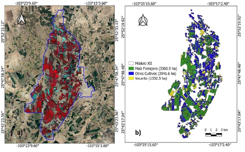
Supervised classification is a technique that identifies spectrally similar regions using training samples extracted from a satellite image. The most used agricultural land cover classification algorithms include minimum distance, maximum likelihood, spectral angle mapper, and Random Forest. This study evaluated the performance of these algorithms in identifying, mapping, and quantifying the area cultivated with forage maize in irrigation modules X and XII of Irrigation District 017 in the Laguna Region, a crop of high economic importance. Sentinel-2 satellite imagery was used, acquired on three dates corresponding to key phenological stages of forage maize, from tasseling to the reproductive milky grain stage. The Random Forest algorithm with 100 decision trees performed best, achieving the highest overall accuracy and Kappa index scores in both irrigation modules. Module X presented overall accuracy values of 79.1% and a Kappa index of 0.63. On the other hand, Module XII recorded values of 87.4% overall accuracy and 0.79 Kappa index. The highest accuracies were obtained with the image from June 11, 2021 (Julian Day 162), when phenological and coverage dif ferences favored the separation of the crops. Forage maize covered the largest surface area in the study region, reaching 44% of the total surface. The classification of forage maize proved to be the most reliable compared to the other evaluated classes in both modules. The precise identification, spatially and temporally, of forage maize allows for the generation of updated and reliable inventories, ef fectively contributing to decision-making in crop planning and management, as well as in the management of water resources.
Downloads
Publication Facts
Reviewer profiles N/A
Author statements
- Editor & editorial board
- profiles
- Academic society
- Terra Latinoamericana
- Publisher
- Mexican Society of Soil Science, C.A.

To learn about these publication facts, click ![]()
PF is maintained by the Public Knowledge Project